

http://news.mongabay.com/2012/0223-conservation_drone.html
Rhett A. Butler, mongabay.com
February 23, 2012
Remote-controlled plane offers bird's-eye approach to conservation.
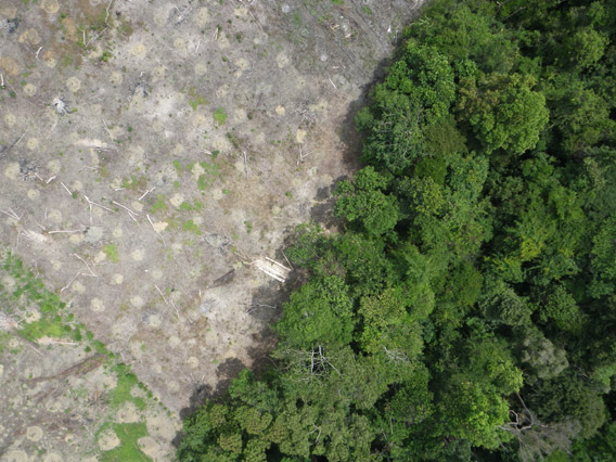
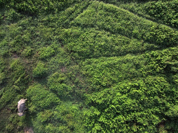
Aerial photograph from the drone showing forest clearing. Courtesy of Lian Pin Koh.
Using seed funding from the National Geographic Society, The Orangutan Conservancy, and the Denver Zoo, Lian Pin Koh, an ecologist at the ETH Zürich, and Serge Wich, a biologist at the University of Zürich and PanEco, have developed a conservation drone equipped with cameras, sensors and GPS. So far they have used the remote-controlled aircraft to map deforestation, count orangutans and other endangered species, and get a bird's eye view of hard-to-access forest areas in North Sumatra, Indonesia.
"The main goal of this project is to develop low-cost Unmanned Aerial Vehicles (UAVs) that every conservation biologist in the tropics can use for surveying forests and biodiversity," said Koh via email. "Drones are already being used for many purposes including the military, agriculture, and even in Hollywood for filming. But they are still not commonly used for conservation purposes."
The reason, says Koh, is the high cost of commercial systems, which can run $10,000-50,000. Koh's first drone cost less than $2,000 and can be carried in a backpack.
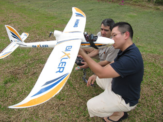   Koh and Wich with their drone. "The idea for developing this low-cost drone came to me during one of my field trips to Borneo in 2004," Koh told mongabay.com. "A very exhausting day of fieldwork made me wish for a remote control aircraft that I could send into the forest to do the work for me so that I could take a break the next day." |
For anyone who has spent hours tracking over rough terrain in the tropical rainforest, the appeal of a conservation drone is immediately obvious.
"This may offer a cost-effective way of counting wildlife over difficult terrain," Stuart Pimm, an ecologist at Duke University who runs the conservation non-profit Saving Species, told mongabay.com. "Having imagery of far higher resolution than from satellites is essential for such work and it offers a viable alternative in places where helicopter or plane costs are too high."
There are also scenarios where a drones can be an alternative to satellite imagery.
"Low-cost drones can be an effective alternative to satellite images for mapping the landscape," Koh told mongabay.com. "In fact, drones can perform better than satellite data in cases where an area needs to be mapped in real-time and repeatedly."
To date, Koh and Wich have used the drone in Aras Napal, close to the Gunung Leuser Conservation Area in Sumatra. During their four days of testing, the drone flew 30 missions — collecting hundreds of photos and hours of video — without a single crash. A mission, which typically lasts about 25 minutes, can cover 50 hectares.
"The drone took pictures of areas where logging occurred, and areas where oil palm are planted right next to a river, which is very damaging to the river ecosystem," Koh said. "It also took pictures of an orangutan who was feeding on top of a palm tree, as well as elephants on the ground. During one mission, the drone also recorded a video showing smoke rising from a forest area. These test missions demonstrate that the drone can indeed be used for the purposes it has been developed for."
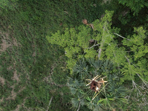
Orangutan (top) and elephant (bottom) as photographed by the conservation drone. Courtesy of Lian Pin Koh.
Koh envisions using the drone to monitor forests, detect fires, and map land use in real-time. He believes the low cost will open up the drone to a wide range of other applications.
"My dream is that in the future, every field ecologist will have a drone as part of their toolkit, since it doesn’t cost more than a good pair of binoculars!"
Koh says the response to the drone so far has been overwhelmingly positive from conservationists.
"We have already attracted the attention of field researchers around the world, who are asking us to go to their study locations for further test flights. These locations include Borneo, Africa and even Antarctica to film penguins!"